Simpósio da exposição Dislocate em Tóquio discute mídias locativas e mapeamentos das cidades. Vejam no link as discussões trazidas por vários artistas. Abaixo um resumo de algumas experiências.
O artista Christian Nold, com o seu projeto “Biomapping” “takes up that paradigm and spatially tracks the users basic emotions through his or her galvanic skin resistance, thus creating emotion-maps of various places, preferably in community-contexts of some sort.” Ele cria mapas sensíveis das cidades a partir de dados biométricos dos usuários.
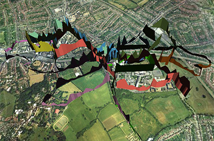
Harrow Emotion map
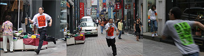
Já Taeyoon Choi é autor do jogo “shoot my if you can’, utilizando celulares e câmeras no espaço público onde as equipes devem fotografar os adversários. Choi está interessado nas modificações da sociedade coreana em meio às novas tecnologias digitais. “The premier of those technologies is arguably the mobile phone/cameraphone. The discourse about surveillance in public spaces is currently merely a western one, focussed on cameras that are operated by the police or property owners. People are hardly offended by those in Korea but, ironically, the same set of issues is going on around the cameras in mobile phones.”
Don Belasco Rogers realiza geografias pessoais das cidades, com monitoramento e traçado de pessoas em incidentes no espaço urbano. Ele realizou experiências em Londres e Berlim : “In order to approach this new city (and to record his London history), he drew a map of such incidents and then matched it with a map of Berlin of the same scale while Picadilly circus and Brandenburg gate serve as center points. Like this, he could approximately tell, where an incident had been if it would have happened in Berlin instead of London and subsequently documented the sites. For instance the place where he tripped and head-butted a lamp-post near Picadilly circus would have been that patch of open space just in front of the Reichstag.”
Segundo o autor, as cidades são “a mnemonic place which lives through its story”.
Dan’s Berlin of 2003
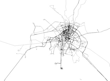
Vejam a descrição dos mapas, os “daily mapmaking” (mapeamentos diários) de seus deslocamentos com o uso de GPS:
“For this ongoing practice of “daily mapmaking” (which borrows from Gerhard Richter’s practice of daily painting), he basically takes his GPS receiver/recorder whereever he goes to trace his ways and watch himself making new connections. The outcome of this project is really beautiful, intricate maps which look a lot like precisely-drawn, slightly technical maps, unless you zoom in and see the inaccuracies of the GPS which suddenly give them something very handmade. Yet, obviously they haven’t been “drawn” in a traditional sense but rather been created by his body’s movement through the real space they resemble, so there’s a whole host of connotations to be found. So now for every day he is in the city, Dan will update the Tokyo-map with last day’s data and it will become more ever more complex as he discovers it.”