EDMONTON
Ha’ dois dias no Canada’ para o pos-doutoramento e praticamente tudo foi resolvido com uma eficiencia inacreditavel: conta em banco, seguro saude, office na Universidade, chaves, ID cards, apartamento, internet (25MB), telefone, luz…tudo. Obviamente nada disso seria possivel sem a ajuda e a disponibilidade absoluta de meu colega e amigo, professor Rob Shields (thanks Rob for all!) e do pessoal do departamento de sociologia que me recebeu muito amigavel e prestativamente.
A cidade, Edmonton, e’ uma cidade plana, nas “praries”, com belas regioes por perto (vejam meu ultimo post), onde os carros dominam a paisagem…Ruas e casas com calcadas quase desertas preenchidas por carros e onibus…Hoje andei por varias ruas e cruzei poucas pessoas no meu caminho…O centro da cidade tem mais movimento e a Universidade de Alberta tem uma excelente estrutura, organizacao e e’ pulsante. Bom, essa e’ a minha impressao com dois dias na cidade. O frio ainda nao chegou e os dias estao belissimos, um azul perola em 12 graus e sol…Vou atualizando sobre a cidade, o Canada’ e a minha pesquisa, como prometido.
CIBERCULTURA
Para recomecar no que interessa nesse Carnet, chamo a atencao para o evento Cibercultura, parceria do Ciberpesquisa/PPGCCC-FAcom-UFBA e do ICBA, no ICBA, Salvador, no dia 24 de outubro as 19 com entrada gratuita. O debate contara’ com os professores Wilson Gomes, da Facom, Ufba, Gustavo Gindre, do CGI, Otfried Jarren, da Suica e ser’a media pelo professor Pinho da ADM/UFBa. O tema e’ internet e democracia. Participem! Como sempre, o evento sera’ transmitido pela internet pelo CPD da UFBA. Vejam o site para mais informacoes. Agendem-se
” CIBERCULTURA V – INTERNET E DEMOCRACIA
A Política no Século XXI – Parte Final do Ciclo!
O objetivo desse debate é colaborar para o pensamento sobre a política no século XXI. Com a cibercultura, surgem temas como governo eletrônico, cibercidadania, ciberdemocracia, voto online, assim como movimentos políticos e micro-políticos em blogs, wikis e dispositivos móveis. A dimensão política da sociedade contemporânea está cada vez mais imbricada em mecanismos de informação abertos e descentralizados, à necessidade de prestação de contas e de oferecimento de serviços em rede pelos governos, na bisca pela liberdade de expressão e de deliberação. O desafio dessa mesa é pensar as diversas dimensões da política e das redes telemáticas na cultura contemporânea.
LOCATIVE MEDIA – MAPAS
Ferramentas de mapeamento estao no cerne das discussoes sobre locative media. Fizemos varias discussoes sobre essa tematica em posts recentes. O Newmediafix apresenta a ferramenta “Hindsight” que permite realizar mapeamentos no tempo. Vejam a descricao:
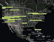
” The two main parameters of locative media are location sensitivity, mostly expressed as longitude and latitude, and time. Locative Media has been developed following the theoretical model of maps. Since their inception, maps have been used to reveal special relationships and realities, and by their mostly static nature, they represent a particular slice of time. With the introduction of web-based mapping new opportunities have arisen, such as revealing spatial data through time. This is a novel direction in locative media – time-based mapping.
Hindsight by Trulia is one of the most poignant examples of time based mapping of information. It allows exploration of historic data in more than half a dozen cities and communities within the United States. The map shows the spatial distribution of real estate related data distributed over time and territories. The experience is both entertaining and informative.
Hindsight is a mapping tool designed to compliment Trulia, a popular real estate listing site, created by Stamen Design. The basic schema includes a map-based context, where one is offered to select among various cities and communities within the continental United States. When selected the map zooms in and an animation of the localized data activates the map in a form of expanding and contracting colored dots. The animation could be stopped and advanced on a year-by-year basis. The central navigation, incorporates color and scale visual clues corresponding to the overlaid data. By sliding laterally one can evoke the overlay for a specific year. Additional tools include the customary map zooming feature and a map brightness controller, which could affect both the aesthetic and utilitarian functions of the overall viewing experience. The site was prominently showcased during the 2007 Where 2.0 Conference in San Jose, CA.(…)
LOCATIVE MEDIA – GAMES
Livro, “Space Time Play — Computer Games, Architecture and Urbanism: The Next Level”, explora a relacao entre locative media e games, mostrando como os games interagem com o espaco urbano. Essa parece ser uma volta aos games pre-eletronica onde o jogo estava sempre ligado a uma pratica do espaco. Com os jogos pervasivos, os asfaltic games ou os wireless street games, essa relacao volta forte com a potencia da localizacao, do mapeamento e das formas de anexar informacao inteligente a locais e objetos por tag eletronicas. O livro que sera lancado em novembro nos EUA pretende abordar esse assunto. Vejam trechos da resenha (no link pdf da introducao e sumario):
“Available to the US in November 2007 from Birkhäuser and edited by Friedrich von Borries, Steffen P. Walz, Matthias Böttger, Space Time Play — Computer Games, Architecture and Urbansim: The Next Level offers readers 62 concise essays and interviews interspersed between 64 game, film and science-fiction book reviews, and 48 game research projects, all brilliantly organized into 5 ascending levels, sequenced into topics that build upon the theory of the editors, that video gaming has come of age as one of society’s most crucial and influential cultural artifacts. Richly illustrated and well populated with important and influential theorists, designers and academics, Space Time Play multi-tasks as a scholarly tome, coffee table guide to gaming, and manual of pop culture memes driven by gaming industry.

(…)Levels 1 and 2 situate the history of computer games as interactive play spaces and connect these basic ideas to the framework of the Ludic Metropolis, or City of Play. (…). In Level 3, Ubitquitous Games: Enchanting Places, Buildings, Cities and Landscapes, the Ludic City is crafted as an actual real-life play space, broken out of the computer console, but no doubt influenced by its tendencies, parameters and tools. (…). In Level 4, Serious Fun: Utilizing Game Elements for Architectural Design and Urban Planning, the Ludic City is envisioned as a proving ground and design tool. (…) In the final chapter, Level 5, Faites Vos Jeux: Games Between Utopia and Dystopia, the editors collect examples of how games and war play an uneasy partnership on the battlefield for hearts and minds across societies, present and future-minded.”