Cidades, Mapas, Imagens e Tecnologias
Depois de alguns dias longe do Carnet vou apontar algumas informações e projetos que colocam em destaque a relação cidade, mapas, imagens e tecnologia.
Abaixo um vídeo sobre alternativas utilizando os telefones celulares, sensores para tornar o invisível visível, ou seja o estado do meio ambiente a que estamos expostos. Aqui as mídias locativas monitoram o ambiente externo revelando aspectos invisíveis do nosso ambiente. Já havia postado sobre essa forma de “participatory sensing” antes.
No network performance, debate com Lev Manovich e Jenny Marketou por email em 2002 sobre o mapas. Interessante pensar, como propõe Manovich, em transformar os mapas em “non visual media”. Vejam dois trechos das trocas de emails:
“Lev Manovich wrote: Lets begin by talking about mapping. I see mapping one data set into another, or one media into another, as one of the most common operations in computer culture. For instance, it forms the basis of a whole field of visualization — taking the results of an experiment and visualizing them as a van animation; or taking statistical data and presenting it as a 3-D shape; and so on. These kinds of mappings are also common in new media. For instance, I have come across a few projects where network traffic was translated into music. One of most well known projects which lies at the intersection of science and art (because it seems to function well in both contexts) also involves this kind of mapping — I am thinking of Natalie Jeremijenko’s wire sculpture which translates network behavior into the movements of a suspended wire. Few questions can be posed here. It is not hard to notice that most mappings go from non visual media to visual media. What about mappings which will go into the opposite direction? Another question which we may ask about what exactly is at stake in these projects aesthetically. I always find myself moved by them — but why? Is it because these projects carry the promise of rendering the phenomena which are beyond the scale of human senses into something which is within our reach, something visible and tangible? (…)
LM: Navigating through Paris using a map of London — how wonderful! This is the kind of poetry and conceptual elegance mappings in contemporary “data-art” rarely achieve, if ever. Most often they are driven by the rational impulse to make sense out our complex world, the world there many process and forces are invisible and are out of our reach. So they take some data — Internet traffic, market indicators, amazon.com book recommendation, statistics of text access in rhizome.org database, or even weather — and map it in some way. (I should note that the similar impulse to “read off” underlying social relations from the visible reality animated many artists in the 1920s, including the main hero of my ‘The Language of New Media Dziga Vertov. Vertov’ 1929 film ‘A Man With a Movie Camera’ is brave attempt to do visual epistemology – to reinterpret the often banal and seemingly insignificant images of everyday life as the result of the struggle between old and the new).(…)”
Ainda sobre mapas, no Infostetics, mais uma mapa de crime. Agora um mapa de homicídios em NY: o interativo Mapping Homicides in New York City, baseado no Google Maps API. Segundo o post, de acordo com matéria do NYT:
“The data is compiled from open-records requests and major crime reports from the New York Police Department, including most homicides, in addition to news accounts, court records and additional reporting. The map will be updated as new information becomes available. Users can filter the data by month and time of day, race/ethnicity, sex and age of the victim or the perpetrator, the weapon used, or the borough the crime happened in. The accompanying news article suggests that New York becomes a more lethal place in the summer months, although the dominant and most important trend involving murder has been the enormous decline in killings over the last 15 years, to levels not seen since the early 1960s.”
Abaixo uma mostra do mapeamento. Discutimos mapas de crimes na última Compós. Textos e relatos sobre essa temática estão disponíveis no site da Compós, no link Biblioteca do GT Comunicação e Cibercultura.

No We make money no Art, um debate com o cineasta Harun Farocki e as relações entre tecnologias e imagens contemporâneas sob o prisma da vigilância. O post comenta algumas de suas obras mostradas recentemente em evento em Barcelona. Faço aqui uma síntese traduzindo alguns trechos. Interessante aqui ver como o cineasta está preocupado com as imagens de vigilância e com a performatividade “hiperreal” das imagens, principalmente em “Immersion”, de 2009. Vejamos:
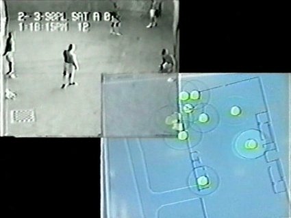
Em Deep Screen ele mostrou 12 telas em tempo real da final da copa, utilizando algumas câmeras de vigilância para mostrar que muita informação acaba matando a informação. Já “I Thought I Was Seeing Convicts”, é uma instalação com duas telas onde em uma é mostrada imagens (de câmeras de vigilância) da prisão de segurança máxima em Corcoran, California. É possível ver Aqui trechos do vídeo. Segundo o post do We Make Money Not Art,
“This video also emphasizes the social relationship between the one who fires and the one who films, between the one with force and the one who takes shots. After that, it takes nine minutes before the convict is taken away on a stretcher”.
A segunda tela mostra imagens geradas por computadores que monitoram consumidores em um supermercado. “Unlike the prison sub-genre that the cinema industry produces, the images that surveillance camera churn out are excruciating to watch. There’s no artificial condensation of time nor space that even the cheapest tv show can create, no close-up, no director trick that would shorten time, no possibility to re-install the camera, sometimes the images have such a low definition they are hard to read. What these images have however is a high level of authenticity, of believability.” Aqui uma entrevista com o cineasta sobre esse filme.
I Thought I Was Seeing Convicts, 2000
O último trabalho do cineasta é “Immersion” (2009) com o uso de realidade virtual para ajudar ex-combatentes a superar traumas de guerra: “He recently attended a workshop where films war veterans undergoing therapy for their Posttraumatic Stress Disorder at the Institute for Creative Technologies, a research centre that develops and uses virtual reality and games to recruit and train the soldiers, but also to treat them. The traumatized soldier has to done a head mounted display and immerse himself into the first person shooter game while a psychotherapist coax them into re-living the most traumatizing moments of their war experience.”
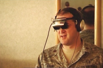
Immersion (2009)
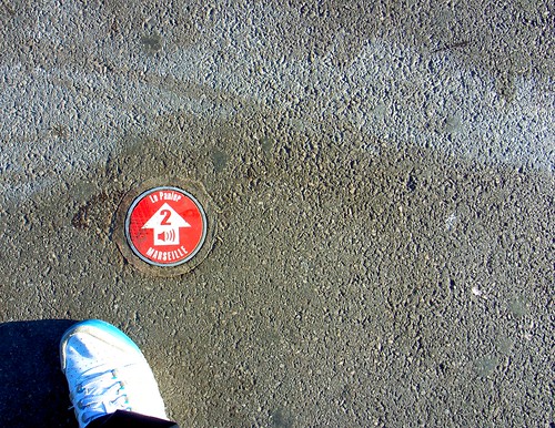
Agora mudando de assunto, mas ainda no campo das tecnologias locativas e do espaço, post do Pasta e Vinagar, mostra projeto de mídia locativa com áudio em Marseille, França:
“A subtle cue on the pavement that indicate that you should press “2? on the audio-guide. An interesting location-based service which do not necessitate a GPS or any other positioning technology. In this case, it relies on people’s curiosity and will to spot this sort of red dot on the pavement.”
E para finalizar uma interessante experiência, também na França, o WikiPlaza, projeto nos moldes da Wikipédia, que faz do espaço urbano um terreno aberto de experimentações na cidade – rede. Por falar em cidade rede, meu artigo Cidade e Mobilidade, falando dessas cidades redes foi re-publicado na revista portuguesa “Intermídias“. Vejam detalhes da experiência da “WikiPlaza” em post no Blog da Vivo: