
Mais um exemplo para as discussões levantadas nos últimos post. Esse vem do blog Digital Urban, Real-Time Data in Second Life, mostrando as possibilidades de importar dados reais para o Sencond Life e navegar por sistemas de informações geográficas (GIS). Vejam:
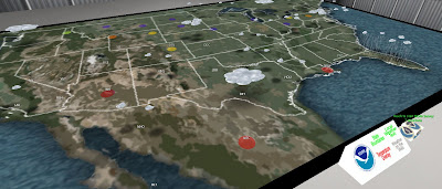
“Importing data into Second Life opens up a range of potential applications from multi-user collaborative geographic information systems to simply tracking your parcels location, traffic congestion or even local transport facilities live online. Part of our current work on Grid Computing and Visualisation of Urban Environments requires real-time data visualisation in Second Life – turns out its already been done . The movie below illustrates two examples of real-time or near real-time feeds: “
Abaixo, vídeo mostrando uma consulta das condições metereológicas e o que parece ser informações sobre voos.