Derivas e Google Maps
Tenho insistido no potencial psicogeográfico e de deriva das mídias locativas, e isso para além dos formatos comerciais que estão surgindo a cada dia. Discuti em recente artigo esses processos de desterritorialização (a deriva, a perda de controle) e de “territorialização” em jogo com as tecnologias digitais móveis. Tenho mostrado em papers e nesse Carnet projetos “bottom-up” de produção de mapas e croquis, abrindo possibilidades participativas de escrita e leitura do espaço. Post do Masters of Media “Can Google Maps set us free? From dérive to (collective) intelligence” mostra bem esse processo.

Teoria da Deriva, na fot movimentos de estudantes do 16th arrondissement de Paris (do Moon River).
Abaixo a definição de deriva pelo próprio Débord:
“One of the basic situationist practices is the dérive [literally: “drifting”], a technique of rapid passage through varied ambiances. Dérives involve playful-constructive behavior and awareness of psychogeographical effects, and are thus quite different from the classic notions of journey or stroll. In a dérive one or more persons during a certain period drop their relations, their work and leisure activities, and all their other usual motives for movement and action, and let themselves be drawn by the attractions of the terrain and the encounters they find there.”
Theory of the Dérive – Guy Debord.
Vejam trechos abaixo do post do Masters of Media:
“Dérive is a notion used by Guy Debord in an attempt to convince readers to revisit the way they looked at urban spaces. The concept means to aimlessly walk, or drift, through the city streets being guided by the momentum and space itself. A modern practice of Dérive is roaming the streets of your city through the satellite photographs in Google Maps and more recently Google Street View; a new feature of Google Maps that allows one to view and navigate high-resolution, 360 degree street level images of various cities (in the US). Google’s maps distinguish themselves from traditional printed maps in the sense that the user is able to interact.

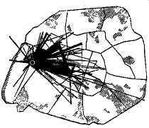
Guia Psicogeográfico de Pairs (via Remue.Net)
(…)
The basic premise in Debord’s theory of Dérive is that people are trapped in the practices of everyday life, by looking at the city by following their emotions they can break with their daily route, routine and enclosed space. Cities in fact are designed in ways to direct and control its publics.
(…)
Bringing an inverted angle to the world can make people assign new meanings to familiar places, produce new forms of social interaction and make public space a place where one stops to look.
(…)
Similarly the satellite photographs in Google Maps changes meaning and memories attached to common places; it gives the user an experience of re-familiarity. Street View on the other hand draws on the recognizable element; the photographs are taken from street level and thereby rediscovering is substituted for virtual sightseeing. The user can now wander through New York while staying at home; moreover, the user can zoom and alter the view at any time. Instead of looking up the fastest route or determining ones location, the function seems to have shifted in the direction of roaming and aimless wandering.
(…)
A wide variety of peer-created extensions are freely available augmenting the information and increasing the amount of knowledge, such as the Wikipedia extension – which provides a sense of temporal accuracy in Google Earth because information is provided about history and coming into being of a particular place, complete with specific dates, adding to the hyper-real situation. The practice of contributing to the medium opposes with traditional one-way media institutions. Google Earth allows users to act upon their creative skills and knowledge by offering possibilities to co-create the product and make it available to anyone, also outside the community. Google Maps API is a tool which users of Google Earth can use to include whichever information to existing maps offered by Google.
(…)
Currently maps are circulating in 3D or data tips containing personal information or photographs taken by users from a street level (which consequently changes the perspective of the original design). Information visualization tools such as maps enable greater understanding of reality, our society, life, and in short our existence. The accessibility and popularity of dynamic digital maps should make academics and interaction designers wonder how new ways of wandering can educate, emancipate, and enlighten the masses.”
